Search Results for 'Briens Bridge'
24 results found.
Was Bodkin’s severed hand a call to Rome?
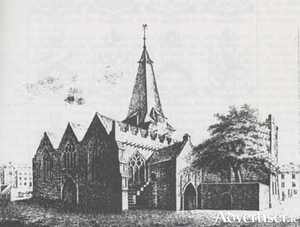
Not only was the saintly Warden Bodkin’s hand in perfect shape and colour despite being lying in a vault for more than 140 years, when it was returned it was crudely ‘cut into pieces, the fingers off from the palm, split into pieces up to the wrist. The skin had been cut off at the breast’. Who could have done this sacrilegious deed? was it a fanatic Catholic seeking a return of St Nicholas’ Collegiate church to the Roman rite; or was it just an act of outrageous vandalism?
Balls Bridge, 1685
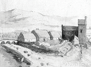
This drawing is of a detail from “A Prospect of Galway” drawn by Thomas Phillips in 1685. It shows the southern end of the middle suburb with Balls Bridge on the left, and the bit of an arch you can see on the far right was part of the West Bridge. Balls Bridge is the bridge over what is now the canal between Upper and Lower Dominick Street, and the buildings we are looking at would be the backs of Lower Dominick Street as seen roughly from across the road from where the Fisheries Tower is today. The West Bridge is where O’Brien’s Bridge is today.
Let's go outside
We have many restaurants and cafes that are fantastic come rain or shine, but as what is rare is wonderful, there is something special about being able to dine outdoors in Galway. Whether you are grabbing a sandwich from McCambridge's and heading to the 'Sp'arch', or having the full three courses outside Kirwan's Lane, it is hard to beat a bit of al fresco. In a city full of well utilised nooks and crannies there is plenty to choose from, apart from obviously the entirety of Quay Street — here are just a few of our favourites.
'Samhain and Macnas suit each other'
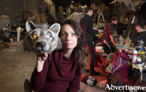
The word “energy” peppers Noeline Kavanagh’s conversation as she talks about her time with Macnas and looks forward to this weekend’s Halloween parade, Out Of The Wild Sky. Kavanagh herself is a human dynamo; though sitting at her office desk she is still a constant whirr of motioning arms, expressive gestures, and infectious enthusiasm.
The Abbey Church
In the year 1296, Uilliam Liath De Burgo started to build a monastery for the Franciscans on a site roughly where the Courthouse is today. It became known as “St Francis’ Abbey on the island of Saint Stephen on the north side of the town”. The island was formed by the river on the west side, and by a branch of the river running through what is Woodquay and Mary Street today, to join the main stream above O’Brien’s Bridge. A second and smaller island lay between St Stephen’s and the town wall, so in order to communicate with the town, two bridges were necessary, one at the junction of Mary Street and Abbeygate Street and the other at the Little Gate.
The Abbey Church

In the year 1296, Uilliam Liath De Burgo started to build a monastery for the Franciscans on a site roughly where the Courthouse is today. It became known as “St Francis’ Abbey on the island of Saint Stephen on the north side of the town”. The island was formed by the river on the west side, and by a branch of the river running through what is Woodquay and Mary Street today, to join the main stream above O’Brien’s Bridge. A second and smaller island lay between St Stephen’s and the town wall, so in order to communicate with the town, two bridges were necessary, one at the junction of Mary Street and Abbeygate Street and the other at the Little Gate.
Taylor’s Bar
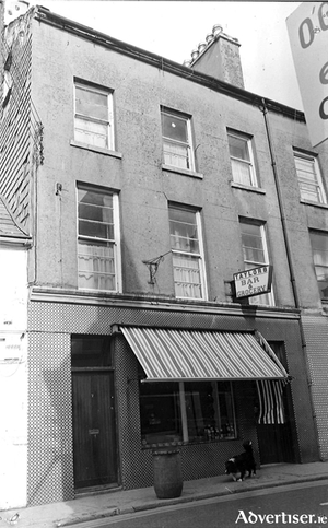
This late 19th century building in Upper Dominick Street was originally a grocery and a pub owned by a family of O’Connells. They used to stable horses out the back. When they sold it, they moved to Dublin where one of them was unfortunately murdered. The pub was taken over by a Mr Cosgrave.
The dredging of the river
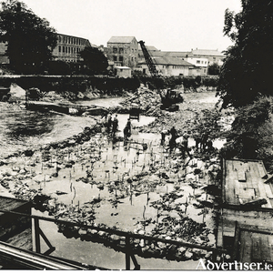
The main channel discharging all the water from loughs Corrib and Mask is the Galway River, flowing from Lough Corrib through the city to the sea. Among the structures built in 1850 and the following years, during the course of a drainage scheme carried out by what was then known as The Board of Public Works in Ireland, was the main regulating weir across the Corrib at Waterside. Its function was to control the river level at Galway in the interests of draining, milling, and navigation. It was built at a point in the river where the water descended though rapids.
City St Patricks Day Parade to celebrate European Region of Gastronomy 2018

This year’s Galway City St Patrick’s Day Parade is set to showcase Galway and the West of Ireland’s rich gastronomic culture and history in celebration of the regions designation as European Region of Gastronomy 2018.
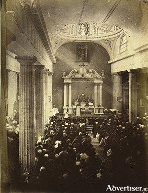
The Corpus Christi procession
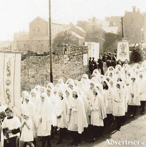
“Upwards of seven thousand people took part in the annual Eucharistic Procession through the streets of Galway on Sunday, when one of the greatest demonstrations of faith in recent years was seen. Practically all of that part of the city’s population which did not take part, thronged the footpaths, and when the procession arrived at Eyre Square at six o’clock, upwards of ten thousand people knelt on the green sward in front of the specially constructed high altar for the final Benediction, which was imparted by his Lordship, Most Rev Dr Browne.

